Idea Forge Technology unveils mapping drone
by sunrise | Sep 14, 2025 | News |
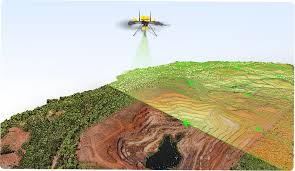
New Delhi- City based drone technology Ltd. On August 20, 2025 unveils its mapping drone for a host of application, including glacier mapping, Complex urban landscape surveys, conducting dense forest studies or monitoring industrial corridors.
The global debut at the company’s inaugural Customer event marks a significant milestone in idea Forge’s mission to equip industries, government agencies and researchers with cutting -edge aerial mapping and intelligent capabilities, it said.
The latest survey GRADE UAV, purpose built to map anything, anywhere with all terrain performance, even in the most extreme environments, offers more than 50 minutes of flight time with a LiDAR payload, weight among others IDEA Force said.
The Q6V2 GEO enables urban planning teams to build 3D city models and conduct infrastructure audits, helps the mining sector Calculate Volumes and automate Compliance reports and supports utility Companies with tower inspection and Vegetation risk assessments,
“The Q6V2 GEO, along with our entire geospatial tech stack is a leap forward in geospatial intelligence, offering our customers the ability to operate in the most demanding terrains and climates with ease and precision. From mapping remote glaciers to surveying bustling urban corridors, this platform reflects our commitment to building solutions that truly advance possibilities. “ said Ankit Mehta, CEO, IDEA Forge. – PTI